research Highlight: Changes to the Monitoring Trends in Burn Severity program mapping production procedures and data products
Authors: Joshua J. Picotte, Krishna Bhattarai, Danny Howard, Jennifer Lecker, Justin Epting, Brad Quayle, Nate Benson, and Kurtis Nelson
This research highlight summarizes an article recently published in Fire Ecology that examines changes to the widely used Monitoring Trends in Burn Severity (MTBS) program and how these changes may impact the user community.
Evolution of the Monitoring Trends in Burn Severity Program
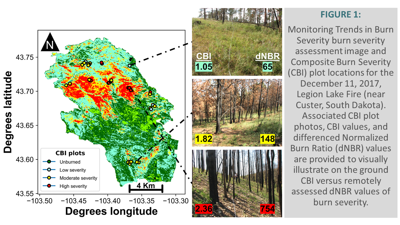
The Monitoring Trends in Burn Severity (MTBS) program has been providing the fire science community with large fire perimeter and burn severity data since 2005. As of October 2019, 22,969 fires have been mapped by the MTBS program and are available from https://www.mtbs.gov. These data have been widely used by researchers to examine a variety of fire and climate science topics. For example, MTBS burn severity products have been commonly compared with Composite Burn Index (CBI) to assess whether the burn severity products are representative of on the ground burn severity (Figure 1).
However, MTBS has undergone significant changes to its fire mapping methodology, remotely sensed imagery used to map fires, and the subsequent fire occurrence, burned area boundary, and burn severity databases. To gather a better understanding of these changes and the potential impacts they may have on the user community, we examined the changes to the MTBS burn mapping protocols and whether remapped burned area boundary and burn severity products differ significantly from the original MTBS products.
Examination of MTBS Data Changes
As MTBS data have been used over the course of many years and for many disparate applications, users should be aware that the MTBS burned area and severity products have been actively reviewed and revised to benefit from more robust satellite image availability and to address any observed quality issues. In a sample of 123 remapped fires, we found no significant change in the burned area boundary products when compared to the original mapped fires; however, significant changes did exist in the distribution of unburned, low, and moderate burn severity pixels within the thematic product. Almost all (97%) of these remapped fires occurred within the western U.S., with California, Montana, Idaho, Oregon, New Mexico, and Nevada accounting for 59% of these remapped fires.
Conclusions
Analysis of these remapped fires provides a look into how the MTBS fire mapping methods have evolved over time. In the future, additional changes to the MTBS data record may impact data users’ downstream applications. The MTBS program has an established continuous improvement approach to the MTBS methodology and products and subsequently encourages users to confirm they are using the most recent data.